
We checked the weather carefully before we left so that we'd have clear sunny weather at Crater Lake. Foiled again. It was snowing as we drove into the park on Friday afternoon and it only got worse as we drove through the park to the campground. It was sticking to the road and there was 3" on the ground in the campground when we got there. It was a no brainer to opt to go down the mountain that night to camp. We found a place at 4,000 feet elevation and it was still 27 degrees the next morning. We decided we didn't really want to drive back up to 8,000 feet to go ice skating on the rim road around the lake so we drove south instead to Tulle Lake just over the Oregon border in California.
We stopped and went hiking in the Lava Beds National Monument at Captain Jack's Stronghold, a natural fortress within the lava beds. Captain Jack was Modok Indian whose people didn't want to be relocated to a reservation in Oregon and they held out against the US forces for five months until their water supply was cut off.
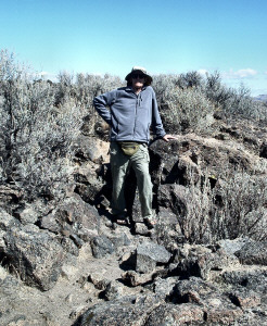
Here's Captain Walter standing inside one of the natural walkways in the fortress.
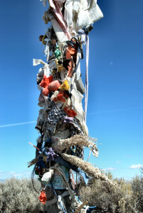
The locals have constructed this prayer tower in the fortress. They leave little cloth dolls hanging on it and stick coins to it with what looks like chewing gum. People leave old bottle caps, expired credit cards and all sorts of other neat stuff around the base too.
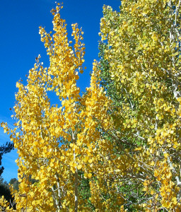
After two more days of driving down Hwy 395 we ended up in Bridgeport, CA south of Reno and just north of the turnoff to Yosemite. The aspens were bright yellow against a beautiful blue sky and when the late afternoon wind died down and I went out and shot a few pictures of them.
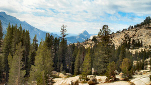
The next morning we finally drove up Tioga Pass (9,945 ft) and into Yosemite's High County. There had been a storm that night in the mountains (they'd had snow at Lake Tahoe) and the clouds were just starting to clear out when we drove into Tuolumne Meadows, the high mountain meadows that are a popular starting point for hiking in the High Backcountry. The meadows had turned brown and it was cold and windy so we didn't stop to go hiking there.
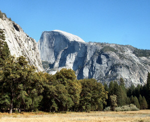
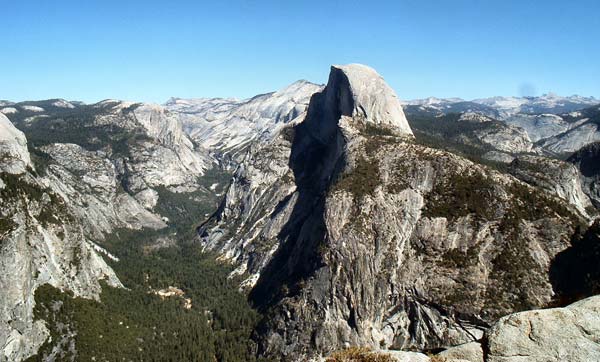
We did stop at Olmstead Point the first place you get a view of the top of Half Dome, one of the dominant features of Yosemite Valley.
Half dome is the lump at the center of this photo. You can see how rugged the terrain is by the yellow sandstone on the right edges of the photo. It's beautiful stark country.
We drove on down to Yosemite Valley (4,000 ft elevation), found our campsite and then set out for a walk in the Valley.
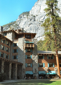
The first stop after wandering around in the woods for a while was the Ahwahnee Hotel which is a National Historic Landmark. It's a grand old hotel with a fantastic views of the valley and wonderful art and artifacts everywhere you turn--along with the obligatory National Park Lodge huge stone fireplaces and high beam ceilings.
From there we hiked on out into Ahwahnee Meadow where I took TONS of photos of Half Dome and all the other massive rock formations that form the walls of the Valley.
By this point we were starting to get tired so we walked on to Yosemite Village which consists of a big grocery store, shops, restaurants and all sorts of other services totally crawling with human kind. It was like being in downtown Seattle during the holiday shopping season! Given that this was not the high season it really makes you wonder what it's like there in July and August. Yikes! We bought a few groceries that we needed and then hopped on the free shuttle to go back to the campground.
They have a whole fleet of hybrid buses to take everyone around the valley so that people will leave their cars behind. We rode the bus through it's complete route to get a feel for things and as the week progressed we really grew to love being able to hop on one of these buses and get where we were going without a car. On that first day, we saw a group of 5 bucks (deer) with full racks just lounging on the grass among the park service buildings along the road. Clearly they know they're safe!
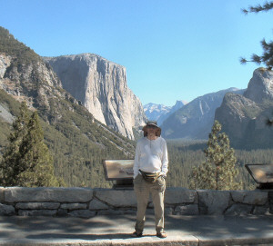
The next morning we drove the road around the valley stopping at all the appropriate view points--looking for rock climbers on El Capitan (we didn't see any) and stopping at Tunnel View which is the traditional first view many folks have of the valley.
That massive hunk of rock on the left is El Capitan, the largest granite monolith in the world. The human in the center is Walter.
From here we drove up the Glacier Point road past Badger Pass, the ski area that is open in the winter, to Washburn Point an incredibly gorgeous viewpoint that lets you see the backcountry of Yosemite AND the valley below all at once.
On the left of the tree is Half Dome and then to the right you can see backcountry that extends for miles south all the way to Sequoia. The Pacific Crest Trail and John Muir trail wind through this back county which is considered some of the most rugged and beautiful on the west coast.
We could see water falls and trails winding all through the area. And up on the top of Half Dome you could see hikers who had left at 7 am to make the hike that includes using steel cables to climb up side of the dome opposite us in the photo to reach the very top. They looked like little black ants from where we stood--even with binoculars.
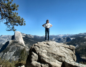
Before we drove on I climbed up on this big boulder and insisted that Walter take a picture of me on it.
From here we drove on to Glacier Point (7,500 ft) which is 3,500 feet above the valley floor. From the view point you can look straight down into the valley and see the campground where we had left our trailer.
There's Half Dome again and the far end of the valley below. If you look down to your left (which of course YOU can't) it's STRAIGHT down 3,500 feet.
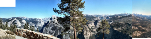
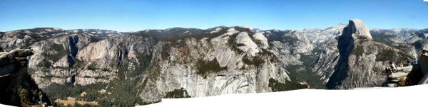
We took a ton more photos including this panorama from the viewpoint encompassing much of Yosemite Valley.
Then we drove back up the road a bit and went on a hike to Taft Point which has overlooks so steep they make the ones at Glacier Point look tame.
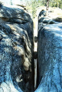
In addition, there are formations called The Fissures that are huge cracks in the edge of the rim that once again go STRAIGHT down. Here's one with a few boulders stuck part way down.
This thing doesn't look that steep but it does go down about 3,000 feet. Heights don't usually give me trouble but standing on the edge of these fissures made the bottom of my stomach fall out like a fast elevator ride.
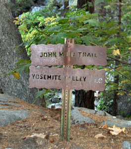
The next day we did the hike to Vernal Falls. It takes you along the John Muir Trail and they have the coolest trail signs I've seen anywhere. They're made of iron and the trail names and distances are punched out like stencils.
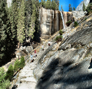
Just past the sign the trail starts to really go up. In fact it gets so steep there are 600 stone steps that lead up to the top of the falls.
This is the not so steep section. To make matters more fun the steps aren't as wide as your feet so when you come down you can't put your foot down all the way. This is not a trail recommended for folks who don't like heights!
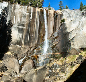
We climbed about 200 steps and got to the bottom of the falls. There was a rainbow and I once again took a ton of photos.
If you look carefully at the bottom of the falls you can see a bit of the rainbow. This section of the trail is called the Mist Trail because in the spring and early summer the falls have so much water coming over them that the trail (and all those lovely stairs) are engulfed in mist--raingear recommended. In a drought year in October clearly that was NOT a problem.
Our last day in Yosemite we took a series of short hikes. On one of them a mama bear and her cub ambled by us. The cub walked along the top of a downed log almost skipping as he went, just like the little kid he was. We were very quiet and they kept going across the valley. We saw them again on our way back on the other side of the valley. We'd seen a coyote the day before in the campground but seeing the bears were especially wonderful.
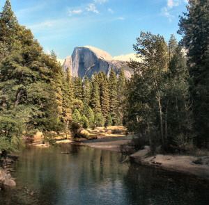
At the end of the day we stopped at the Sentinel Bridge which is one of the most classic photo ops in the park. If the Merced River is perfectly still you can see Half Dome reflected in it. For us it was close.
A storm came in during the night the last night in Yosemite. We awoke to hail in the night and it was still at it in the morning. We got to sit warm and dry in the trailer eating our breakfast watching a group of middle school students scurry around in the hail trying to pack up the gear to go home from their school sponsored camping trip.
As we drove out of the park we noticed signs announcing that Tioga Pass and Glacier Point Road were both closed due to snow! Just 4 days before Tioga was clear cool and sunny and 3 days before it was in the high 70's and folks were in shorts up at Glacier Point. Things change fast in the Sierra in the fall!
We drove south out of the park and the further south we got the more snow we encountered. Bad sign since we were going south to Sequoia which is at 8,000 ft. We stopped for groceries in Fresno and took time to call the Lodgepole Visitors Center which is right next to the campground we were headed for in Sequoia. They told us it was 22 degrees and snowing and snow tires or chains were required on the road.
Hmmmm, time to regroup again. We found a low elevation campground near the south entrance of the park (rather than the north end where we'd planned to go) and set off for the little town of Three Rivers.
The next morning it was cold and clear and you could see the mountains so we drove up to the park entrance in the truck leaving the trailer at the campground. Good plan, since they stopped us at the park entrance and inspected the tires to be sure they were snow tires--the trailer would have required chains.
The road from the south is narrow and full of switchbacks. It took us 1 1/2 hours to drive the 30 miles from the entrance to the Big Trees. And it was worth the drive! There was snow still on the road and the trees were still frosted with snow too. We did a hike through Big Tree Meadow that was so beautiful it moved me to tears several times.
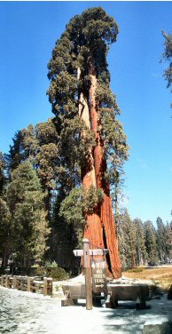
I sewed this photo together from two shots so you could at least see the first tree on the trail!
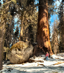
Here I am standing at the foot of one of the big trees next to a boulder. Without me to provide scale you might not realize how big the boulder is or how big the trees are either!
From here we went on to the trail that leads to the General Sherman tree, the largest living thing in the world. He's an old tree with the top broken out. Sequoias do this regularly as they age but they keep on growing in girth--kind like all of us. He's surrounded by a bunch of other trees and the clouds were starting to come back so it was a bit too dark to get a really good shot of him. But I did get some nice shots of the nearby Congressional Grove.
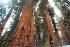
It's not easy to get a photo of the groves but I think this one does a pretty good job of giving you the feel of what it was like to be there on a cool fall day.
The next day we decided to start the drive home rather than take spend 3 hours driving up and back again to try to hike in the snow where many of the trails were closed.
Instead we headed for the California coast and Hwy 1 starting just north of San Francisco. This is the most winding road I have ever driven. It makes Hwy 1 through Big Sur look like a very straight, wide super highway. Since we were pulling the trailer, we were averaging 20 MPH.
It was Sunday and it seemed as if the entire Bay Area was out for a Sunday drive on this gorgeous road. All the restaurants we passed offered barbequed oysters--however, we did not stop to for this culinary experience. We spent the night in Bodega Bay and the next morning continued north where the road got a little better and the views were gorgeous.
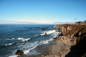
There was fog JUST off the coast so we stopped early to take photos. And that was a good thing because as we got further north the fog closed in and while the road was clear the views disappeared. It was a long drive but we're glad we did it and now know that if we ever do it again we won't do it hauling a trailer!
We spent the night in Trinidad, a little town north of Eureka, and then drove up through Redwood National Park--the worlds TALLEST trees not to be confused with the Sequoias which are the BIGGEST (they're not as tall but they're bigger around).
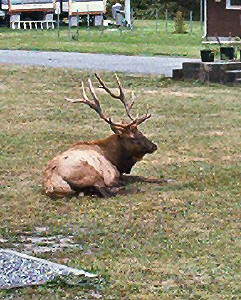
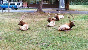
As we came through the little town of Orik there was a big herd of elk--one big buck and an entire harem of females with him. Then not very much farther along the road we came to a stag party!
There were about 15 males lounging around on the grass in what is normally an RV park. They were kind enough to sit still for all the tourists who pulled over to gawk at them and shoot photos.
We made it to Eugene that night and it started to sprinkle just as we pulled into our campsite--a bit of welcome home to the Northwest after all those lovely sunny days down south.