
That's a far cry from what we found there last year on the 28th of September when we had snow and temps in the low 30's in the middle of the afternoon.
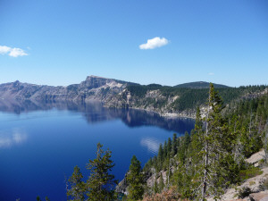
This time we had no problems with fog or blowing snow! Instead we had mirror-still conditions and blue skies which made for gorgeous blue water and reflections.
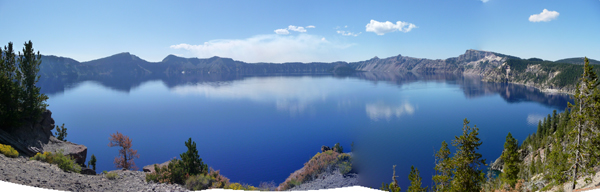
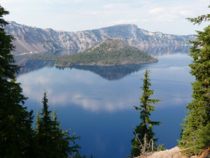
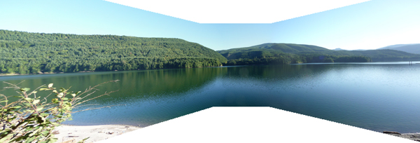
There's a 33-mile long rim road that runs all the way around the lake. We stopped at every turn-out and I took pictures at every one. I promise not to drown you in them all--I sure had fun though. Instead, here's one of the better panorama's I managed to sew together.
And here's another shot that gives you a sense of both the quality of the water and the terrain. It was nice to have a few puffy white clouds arrive as the day wore on to add some interest to the photos!
Once upon a time long long ago, Crater Lake was a 12,000 foot high volcano. It blew it's top about 7,700 years ago and collapsed into itself. It continued to be active for a while and formed several of the formations that now appear as islands. Finally it sealed itself up and filled with melted snow and rain water. The lake has no inlet or outlet. It just fills itself each year from the enormous amount of precipitation that falls here--44 feet of snow for starters!
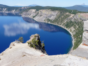
This photo was taken near the only trail that leads down to the lake's surface. There's a boat that you can take around the lake. But since the hike takes an hour each way, and the boat ride is several hours we opted not to dedicate half a day to it. Another time perhaps.
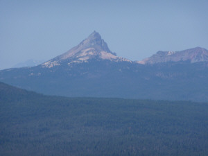
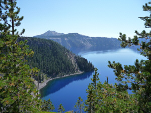
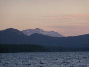
Mt. Thielsen is just north of the park up by Diamond Lake and there are great views of it on the way to Cloudcap, the highest viewpoint in the park.
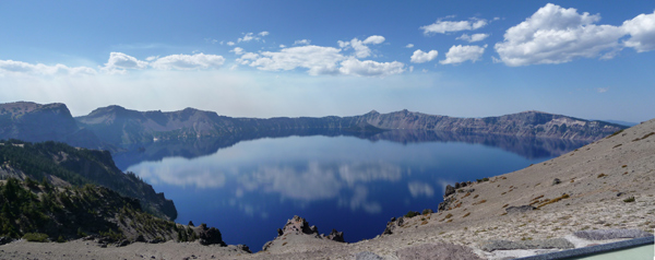
This is a panorama I shot from Cloudcap.
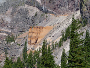
After Cloudcap you come to Pumice Castle. It's an eroded extrusion of orange pumice that they say looks like a medieval castle.
To me it looked like someone has taken a bit of Bryce Canyon and dropped it in on the crater's wall.
After Pumice Castle you come to the first overlook where you can see a formation they call Phantom Ship.
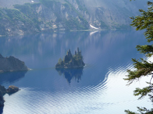
The tour boat passes between the ship and the shore on your left and someone had seen it earlier in the day and was sitting waiting to get a photo of it. Since there were only about 3 boats a day and there isn't one between 11 am and 3 pm, we all figured she was going to be there a LONG time.
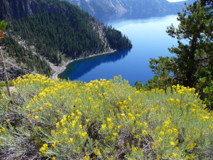
As usual, I did manage to find a flower or two. Here's some rabbit bush in bloom along the rim. I like the contrast between the yellow and the deep blue of the water.
After driving a while more we came to a trailhead called Sun Notch. Walter was working on conserving energy--we were over 7,000 ft after all--but I needed to stretch my legs after being in the car for so long, so off I went. It was one of those impulses that paid off.
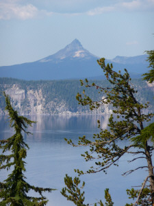
First there was this great view of Mt. Thielsen with the lake in front of it!
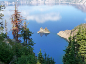
And then from just one overlook you could see the Phantom Ship--with the sun shining on it!
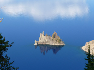
I love how I managed to get it's full reflection simply because the water was so calm.
Towards the end of the drive we came to the one little bit of 'civilization' along the rim: Crater Lake Lodge and Visitor Center. There were folks talking on their cell phones and dragging their luggage along the path towards the hotel!
From this area there are great views of Wizard Island--a cinder cone that formed after the original mountain blew her top.
In case you're curious, Crater Lake is 1,943 feet deep and it's water level only varies 3 ft even though it's fed entirely by rain and snow. The park stays open all year but you can only get to the area by the hotel (which doesn't stay open). They close the rim road to cars but you can cross country ski or snow shoe on it.
During the day we had watched smoke rising to the southwest of the park. It turns out there was a good sized forest fire burning in the Wilderness area to the southwest along with the one burning to the northwest of Diamond Lake. By the time we got back to Diamond Lake it was pretty smoky since the wind has shifted and was blowing our way.
We'd planned to stay another day and go kayaking on Diamond Lake but when it was still smoky in the morning we pulled up stakes and drove north to Waldo Lake where there weren't any fires. I'd seen photos of Waldo on-line and it looked pretty swell. We went and did a 'where's Waldo' search and discovered there were nice campgrounds and boat launches too.
Once again we found a water view campsite. It was a beautiful day and we had time to sit in the sun and read and then watch the sunset.
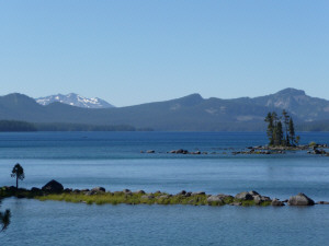
This is Mt. Diamond to the south.
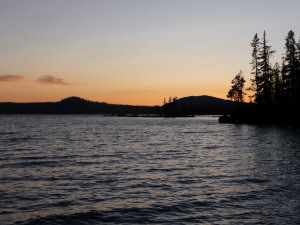
The trees on the right are on a little island that sheltered our section of the lake from the wind and made a little lagoon.
The next morning it was a little windy so we went for a hike along the lake waiting for things to calm down.
Later we made a picnic lunch and set out for a little islet that someone had told us they'd canoed to the day before.
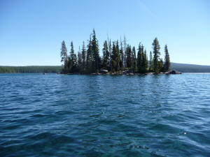
Here's the islet. It turned out to not be all that far of a paddle and after paddling all the way around it once we found a shallow area to put in, beach our boat and have a look around.
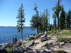
It had this nice little bench and a picnic table but we weren't really ready for lunch yet. So after enjoying the view we put back in and kept paddling until we found a little cove with a beach where we could have lunch.
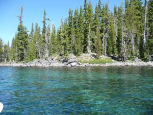
The water was incredibly clear and in areas where there was sand on the bottom it turned this marvelous aquamarine! There's supposed to be fish but we didn't see any.
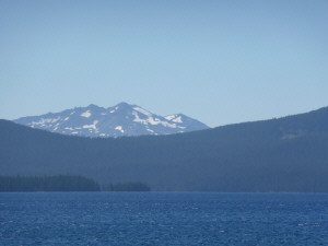
Here's Mt. Diamond from the boat.
We didn't see a single motorized boat on this lake even though they're legal. It's a big lake--the second largest natural lake in the state after Crater Lake but it's somewhat remote. It's surrounded on 3 sides by Wilderness. It's really popular with kayaks and canoes though. In fact, I've never seen so many anywhere before! It was beautiful and quiet and I'd certainly be happy to return to visit again.
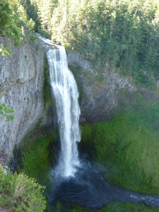
The next morning we began our journey homewards. We stopped at Salt Creek Falls which is just west of Waldo Lake on Hwy 58.
That night we camped at Swift Reservoir which is just south of Mt. St. Helens (we're back in Washington now).
This was the view from our campsite. Swift is the first of 3 reservoirs in a row that supply power to the Vancouver-Portland area.
Because it's the first in the series it ends up with LOTS of driftwood each year--washed down from the mountains in winter storms. Here's the pile they'd collected this year at a cost of $100,000. And there was still tons of the stuff along the beaches that were becoming exposed as the lake was drawn down this fall.
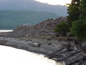
We asked what they were going to do with it and it turns out they're going to burn it. Talk about a bonfire!
The next morning we headed home the back way so we could get a view of Mt. St. Helens' south and east faces.
Here she is with just a little bit of last winter's snow over on the left.
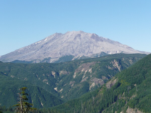
The trees on her slopes and the surrounding area have all grown in since the May 18, 1980 eruption. It's pretty funny because they're all the same height until you get out of the blast zone and into areas where the older growth trees survived--then they are all different heights.

It really is amazing how well everything has recovered in just under 30 years.
Just after our last view of Mt. St. Helens we caught this glimpse of the south side of Mt. Rainier.
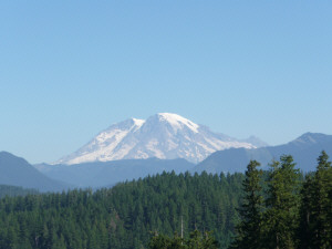
We drove north and west a ways and came around the bend to see her again this time from the west. I pulled over in a turn out and hiked back up the road so I could get this shot.
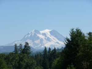
She's a beautiful mountain, don't you think? It's always so nice to come home and find her out and strutting her stuff.
We had a great time visiting Oregon's mountains, lakes and waterfalls. I hope you enjoyed going along with us.