
We closed up all the vents and windows and put on the air conditioning and in less than an hour the temperature was down to 75. By 7:30 that evening, the temperature outside was comfortable enough for us to open all the windows and let the breeze blow through. The Airstream has GREAT cross-ventilation. Next time we get the awnings all up and the windows all open I’ll take a picture since the Airstream looks like some kind of exotic bug with all of them deployed.
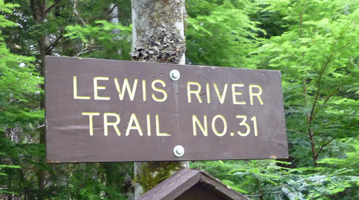
On Wednesday morning July 2nd we managed to get the big awning back down again (with only a couple of little hitches) and we headed on down the highway towards Cougar WA. For those of you with no clue (most I would suspect), Cougar is about 30 miles east of Woodland WA on I-5. We had lunch in Cougar and then drove another 30 miles northeast on Forest Road 90 (actually paved most of the way) to Lower Falls Recreation Area on the Lewis River. Along the way we got two nice glimpses of Mount St. Helens but there was no place to pull over so I couldn’t take a picture.
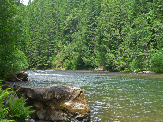
The campground was about 1/2 full when we arrived in the late afternoon and we found a nice long paved (level!) back-in spot that the trailer fit in nicely. There are quite a few good sized back-in sites here. No power and only one hand pump for water for the entire campground. But they have trash and recycling pickup!
We set up camp and stopped and talked to the campground host to ask about the 4 waterfalls our campground book said were within 15 minutes of here. She is a fifth grade teacher from Grand Coulee who grew up in White Salmon on the Columbia Gorge. She got her job here by writing to the ranger for this district and asking for a spot near where she grew up so she could visit her family during the summer. They gave her this campground which is about 65 miles from White Salmon and she’s delighted. She has no hook ups but they provide her with a big propane tank, a generator, fire wood and a satellite phone for emergencies. She walks her dog through the campground once or twice a day, keeps the bathrooms stocked with toilet paper and answers questions. That’s it. She doesn’t have to clean any of the sites or the bathrooms. She doesn’t have to collect money or do anything about reservations (they don’t take reservation here which is why we chose it for the holiday weekend). She can roam around and hike as much as she wants. And she’s out in the middle of nowhere on the south face of Mount St. Helens.
By Thursday morning July 3rd, the campground was nearing full but there were still a few folks driving around looking for spots. We were in the lower loop which has access to the river so it fills up first. The Upper loop filled up too with many of the sites having multiple vehicles.
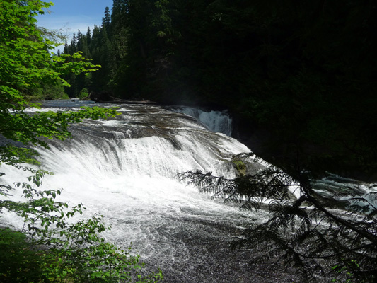
We set out to find the trash and stopped by the campground host again to visit. Then we found our way on the Lewis River Trail to the Lower Falls overlook which is right on the edge of the campground. These are pretty big falls and very satisfactory.
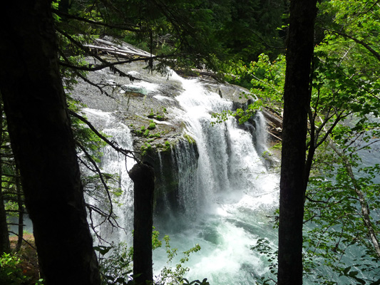
The native people’s used to catch salmon at the bottom of these falls. Now the area is catch and release—there are bull trout in the river and you have to throw them back even when it’s not catch and release.
If you head up river on the trail you come to more views of other portions of the falls.
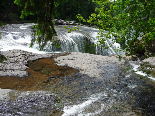
And stairs down to even more views.
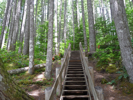
Here’s proof that my knee was doing much better. I came down these stairs without much problem and going up was no sweat at all. The forest here is second growth but very very nice.
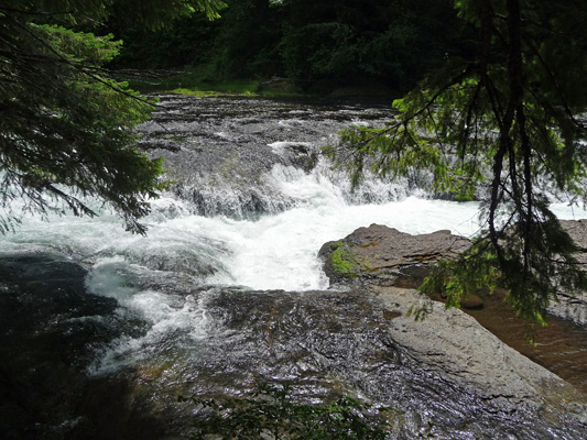
We climbed back up the stairs and followed the trail along the river until we could climb down another set of stairs to the beach along the river.
There are rapids that start just off to the left but I couldn’t get a good photo of them.
We’re working on just hanging out (something that is a bit of a challenge for us). It’s good for my knee and we’re much less likely to get over-tired that way. As we discovered on our trip to Alaska, being on the road for extended periods of time can be really tiring. So we’re trying to give ourselves more rest days and learn to just hang out in these beautiful places rather than feel we have to be out exploring and hiking every day.
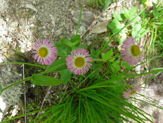
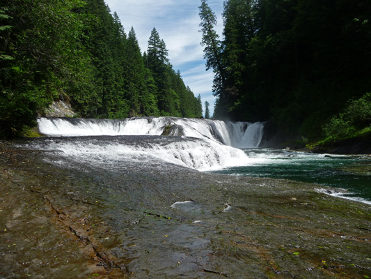
On 4th of July, we got into the truck and drove a mile up Forest Road 90 to the trail head for Middle Falls. They didn’t say how far it was but when we’d looked at the topo map in the campground it didn’t look like it was too far off the road. The trail goes down a rather steep path over loose scree and then out into level forest. In a little while, it descends to the Lewis River Trail. The trail gets muddy in places where the hillside seeps down onto the trail. There were mimulus blooming there and these asters too. I think that these are Three-nerved daisies (Eigeron subtrinervis) but I easily could be wrong.
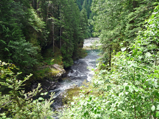
You follow the trail up river and eventually it comes down towards the river and you can see a series of rapids.
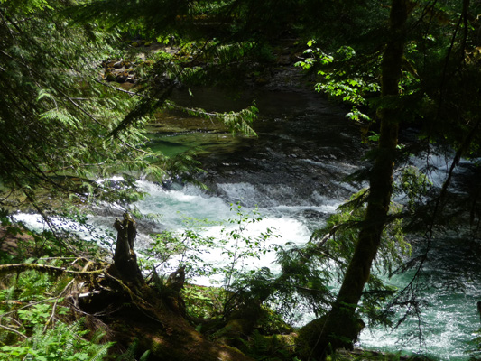
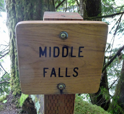
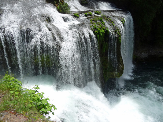
There was a big group of people down by the river not far from here and we guessed it wasn’t far to the falls. We were right and to verify it there was even a sign identifying the falls.
The river has been eroding the trail so finding a good place to stand to take a photo was a bit of a challenge. I scrambled around a bit and managed to get a decent shot.
Having done all this (with a lot of fairly steep down) it was time to rest my knee. So we went back to the area at the river bank and rested for a while. There was a group of 3 families who had gathered for the long weekend and were out hiking—14 of them in all. One of the kids had done the hike barefoot and they’d all decided they’d sign his feet with a Sharpie pen. Great fun.
When they left we wandered down to the river and carefully picked our way across the slime-covered rock ledge to stand out at the river’s edge. From here you can really tell what a nice waterfall this is.
Then we made our way back UP the trail and when we got to the turn-off to the trailhead we saw that the sign said it was 1/4 a mile. We figure we hiked 1/2 mile to the falls and then 1/2 mile back. Normally this would have been a waltz in the park. But for me, with my improving but still gimpy knee it was a major victory. Not only did I hike DOWN (much harder then up) and back UP again but I managed a good mile too without my knee actually hurting. Hurray for major improvement.
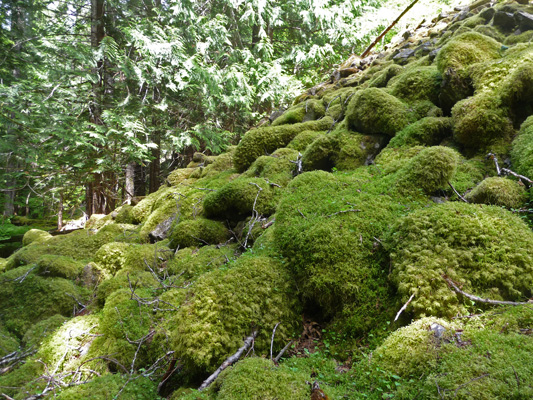
Just before we hit the last big rise (with the scree) we spied these mossy rocks where the forest shades the scree. Pretty cool, huh?
We then drove out to see how far it is to the trailhead for the Upper Falls—just another mile.
After celebrating 4th of July without hearing a single firework or gunshot go off, we awoke to yet another mostly sunny day, though a little warmer than the day before.
We’ve discovered that we need to run the generator 1 1/2 hours in the morning and again in the evening to keep up with the drain of all the Airstream’s monitoring systems and our use. So after breakfast we ran the generator and then motored out the 2 miles to the parking area for the hike to Upper Falls. There’s a big information board which was no help. It was all about the Mount St. Helens area campgrounds which lie west of here. We set off into the woods only to discover a few HUGE trees had fallen across the trail and the spur trails just ended abruptly. We saw some folks on the trail heading back to towards the road and asked them, and they thought the trail was across the road. Since that made no sense we went back out onto the road and started the tail just east of the parking area where a sign indicated the beginning of the Lewis River Trail.
The trail headed along Quartz Creek flowing towards the river. This made sense to us. And sure enough not long afterward we met some folks coming toward us who had been out to the falls and were on their way back. They said it was quite a ways—maybe 25 minutes—to the falls and that first you came to another falls. Ah ha! Here was the 4th falls that our campground book had talked about but the campground host knew nothing of.
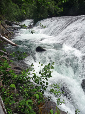
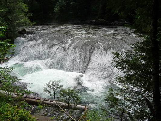
The trail winds downhill towards the river and then turns to parallel the river for a ways. You can hear rapids even if you’re pretty far above the river. And then sure enough there’s a little spur to a viewing area for the falls.
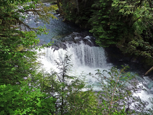
The main falls are followed by a shorter cascade.
Just west of the falls there was a nice old sign telling us the name of the falls.
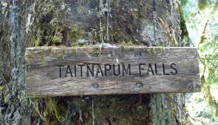
That’s very close in spelling to Taidnapam Park where we stayed last week. But I’m sure the change in spelling means a change in meaning too or not.
The trail opens up now and then to give you a view of the rapids on the river.
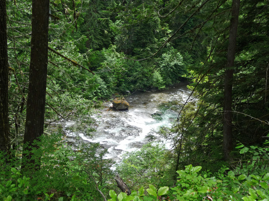
And at one point you could actually see a long run of the river as it rain towards Upper Falls.
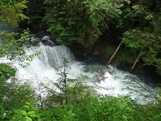
The trail takes a very steady downward turn as you approach the falls and then gives you the option to take a switchback trail down to the falls themselves. We of course took that option, though my knee wasn’t thrilled with the very steep down in places. It was worth the trip though.
If you walk to the left of this picture you can see that not all of the water comes over this rocky ledge. A great deal comes over the side of the ledge and then down this shoot.
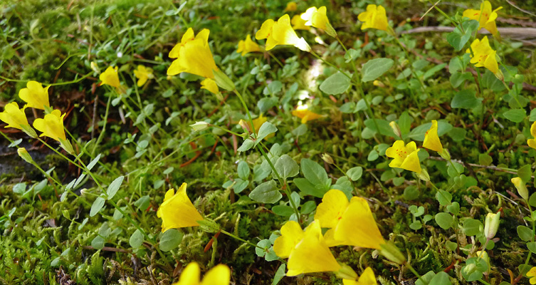
There were small yellow monkeyflowers (Mimulus guttatus) growing in the mist on the rocks facing the falls and out on a few logs jutting into the spray.
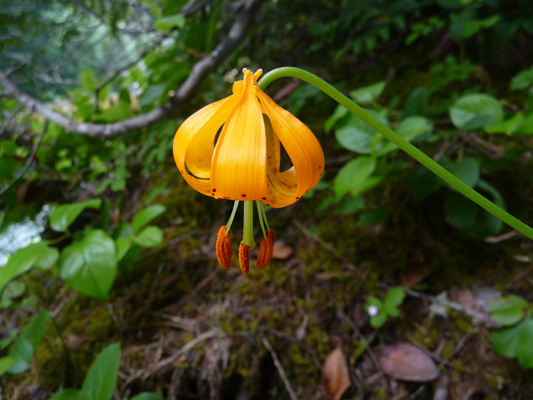
And one lone Columbia Lily (Lilium columbianum) in bloom in a patch of sun.
There’s a viewing area (delineated with railing--a sure sign that this is a viewing spot) that was a ways back from the falls and gave a nice photo op and a very different take on the falls.
There was another big fallen tree over the switchback trail that had made coming down interesting and it made going up even more of a challenge but we made it. Up until this point we’d had the trail to ourselves. As we were sitting recovering from the hike back up to the main trail, 10 people (2 parties of hikers) all arrived at once. Boy, were we glad we’d had the falls to ourselves for a while.
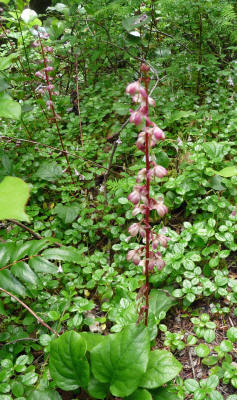
Along the long uphill grind on the way back along the trail, I noticed a patch of Pipsissewa (Chimaphila umbellata) and got down on my hands and knees to photograph it.
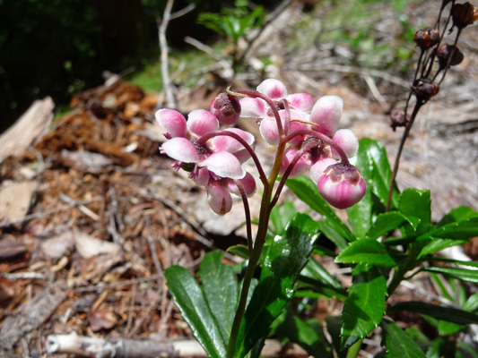
There was also this wonderful long spike of Bog Wintergreen (Pyrola asarifolia).
We don’t know how far we hiked but it was further than the day before so let’s call it at least 1 1/2 miles. It was pretty steep in places and aside from the knee getting tired, it didn’t hurt. This is very good news. I’m still black and yellow where my knee hit the hitch and to be able to hike this far means no REAL damage. Whew.