
2014 ADVENTURES
- June
- Sequim
- Salt Creek
- Cape Flattery
- Marymere Falls
- Hoh Rainforest
- Ruby Beach
- Schafer
- Kachess Lake
- Rimrock Lake
- Taidnapam
- Baker Lake
- Silver Falls
- July
- Lower Falls
- Oregon Cascades
- Newberry Crater
- Oregon Coast I
- Oregon Coast II
- Oregon Cascades Part II
- Eastern Oregon
- Oregon Cascades Pt III
- August
- Oregon Cascades Pt IV
- Oregon Cascades Pt IV
- Oregon Cascades Pt V
- SW Washington
- Mt. St. Helens
- Mt. Rainier Pt I
- Mt. Rainier Pt II
- September
- Eastern WA
- Issaquah WA
- October
- OR Waterfalls Pt I
- OR Waterfalls Pt II
- Central OR
Oregon Waterfalls Oct. 2014
After getting the all clear on the state of Walter’s eyes after his second cataract surgery (he has 20/20 vision now), we set out on Tuesday October 7th for a three-week trip to Oregon to visit the places we’d skipped when the weather was too hot.
Our first stop was in Covington WA to spend the day at the Airstream dealer where we had a number of issues repaired under warranty. We hung out at the library in the morning (free WiFi) and did errands in the afternoon and then spent the night at the Washington Land Yacht Harbor (yes, it’s an RV park dedicated to Airstream trailers). The sun had come out late in the afternoon, so we got to see the orange full moon as it rose but the fog and clouds came back in during the night.
On Wednesday morning we set out in the foggy overcast to head south. By the time we reached the Washington-Oregon border the sun was out and we had blue skies. Hurray! We got off I-205 in Portland at Clackamas and took the winding country bi-ways out to Silver Falls State Park outside of Silverton, OR. We’d camped and hiked here in June of 2004 and really enjoyed it so a return in the off season seemed like a good idea. We got a spot for two nights (they were full for the weekend!) only to find that there was a fiberglass trailer gathering going on so we were surrounded by Escapes and Casitas and a few other strange rigs we’d never seen before (though our next door neighbor was another Airstream).
The skies stayed clear and we got to see the full moon as it rose over the trees. It stayed clear that night so it was pretty cold in the morning but the blue skies were welcome. After having breakfast and making a picnic lunch we set out on our outing for the day.
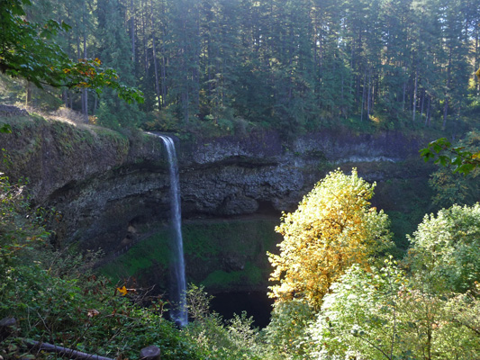
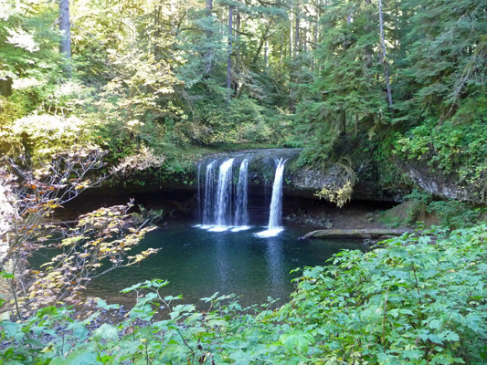
First stop was the Day Use Area for the South Falls. There are over 10 waterfalls in Silver Falls State Park. The last time we were here we hiked the upper section of the Trail of 10 Falls and saw nearly all of the falls. This time we were cheating since we wanted to visit another set of waterfalls nearby. So we just stopped at the overlook of South Falls to catch a photo. The park is much more developed than it was 10 years ago. The original buildings here were built by the WPA and the CCC in the 1930’s. They seem to have been renovated in the last 10 years and everything looks very spiffy. The Café was even open for lunch and there was a Nature Store open too. The park is very popular in the summer and there are large group campgrounds and a conference center here too.
The hike out to the over look is short and paved with fancy pavers. There wasn’t a lot of water in the falls but enough to make me happy. The trees that had started to turn color added a nice touch of gold to things.
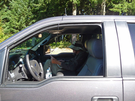
There’s no cell phone signal in the main portion of the park but if you drive west along the highway you come to the South Viewpoint where there is a signal. We stopped there to check the weather report for the next few days. Here’s Walter checking his email. The little antenna on the roof of the truck is for our signal booster. The service was slow but we got what we needed to plan the next few days of our trip.
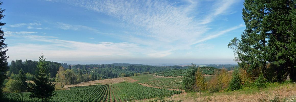
While Walter played on the computer I wandered out to the viewpoint and took a panorama shot of the valley. They grow a whole lot of Christmas trees in the area. Some of them even had tags on them ready to be cut and hauled to market come November. They view them as a farm crop and you’ll see signs that say they grow Christmas trees and seed crops.
From here we set off west and then north to the town of Silverton so that we could meander out to Butte Creek Falls. We’d found the directions to this place in our 100 Classic Hikes of Oregon book and they were perfect. We even managed to find Crooked Finger Road which eventually became gravel. The spur off Crooked Finger to the trail head was washboard and wound through a very recent clear cut. But then the fun began. They were in the midst of re-grading the gravel road and there was a hummock of gravel down the middle of the 1 1/2 lane road. First I tried driving on the right side but there wasn’t enough room. So I drove part of the way with the hummock of gravel under the truck. But then it got too high and I was shaving off the top of it with the underside of the truck—which didn’t seem like a great idea. So I tried driving on the left side which mostly worked. That is until the grader came around the curve straight at us. Oops. I put the truck in 4 wheel drive (a first for me) and pulled over onto the grassy verge and stopped. The grader went on by and thankfully I easily got back on the road. Whew. When we drove out, the road was all nicely graded and the grader had disappeared. Maybe they will re-grade the washboard section next.
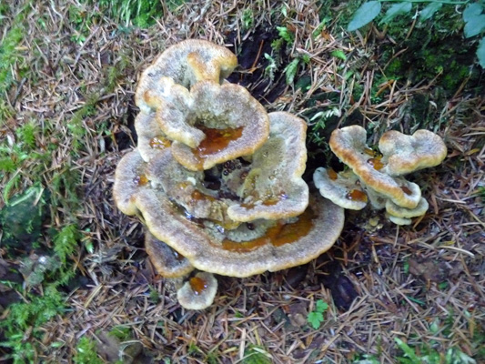
The trailhead for Butte Creek Falls was nicely marked and had space for maybe 4 cars. We were the only folks there. There was even a vault toilet that had just been cleaned (and it had toilet paper!). There was great fungus growing at the start of the trail.
The trail heads downhill fairly quickly and shortly you can hear the rush of water. To the left there is a short spur trail (which goes down some more) where you can view the Upper Butte Creek Falls.
You can go all the way down to the pool and play in the water if you want to.
The rainy season hasn’t begun in earnest yet so there’s not a lot of water in the falls but I kind of like these falls as they are, rather than gushing with tons of water. The area behind the falls that looks like a grotto was created by erosion. It turns out that this whole area has two layers of basalt laid down by the Cascade volcanoes 15-16 million years ago. In between the layers there’s about 20 feet of sand and that gets eroded by the waterfalls and makes these grottos.
We hiked back up the spur and on ahead to the point where there’s a sign that says this is the ‘end of the maintained trail’. You can hear the Lower Butte Falls but you can’t see them from here. If you follow the very clear trail on just a ways and out on a rocky ridge you can see the falls.
Walter stayed here and I scrambled a ways further out on the rocky spine so I could see the falls a bit better.
There was still a more faintly defined trail that scrambled down the cliff but I wasn’t interested in breaking my neck so I turned back.
We hiked back completing a nice loop that takes your up the hill and through the woods. This is a very nicely maintained trail with a very nice bridge near the falls. It’s only about .8 of mile but they consider it moderately strenuous because it’s pretty steep. It was a big surprise that it was in such great shape since it truly is out in the middle of nowhere. It and the nearby campground (3 sites) are run by the Oregon State Forestry Department since it’s in the Santiam State Forest. They’re doing a very nice job of it too.
We drove on down to the campground thinking we could have our picnic lunch there but discovered it was closed for the season. So we drove on back on Crooked Finger Road (can you tell I love that name) to the little town of Scott’s Mill and had our lunch at their city park. Then we made our way back to Silver Falls State Park and drove out to the trail head for North Falls. Walter took a little nap while I hiked out to the first place you could see the falls.
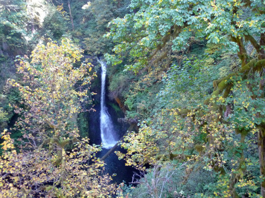
Then we stopped at the North Falls viewpoint to get a photo there. You can see that North Falls has a grotto behind it too. In fact, the trail goes behind the falls—we did that back in 2004.
If the weather had been going to hold we would have stayed and hiked part of the 10 Waterfalls Trail again. But with rain on the way and the fact that we couldn’t get a spot to camp for Friday night in the campground, we moved on to Waterloo Park and another great waterfall hike.
It was sunny and gorgeous again on Friday morning Oct 10th. We gave some of the Fiberglass Trailer Rally folks a tour of the Airstream before we set out and they told us about a really nice county park with electrical and water hook ups that was real near the waterfall hikes we wanted to do. We motored on down the blue highways to the little town of Waterloo and found the Waterloo County Park without any problems. Most of the sites were empty and one of the campground loops was closed for the winter so we found a nice big spot with no problem. This is a nicely laid out park with long paved sites and a nice grove of maples and alders in the middle. It’s on the Santiam River so there are lots of fisherman here.
We set up camp, registered and checked to see if we had a hot spot signal. YES! And we had cell phone signals too. Wow, what luxury. We checked our email and then set out for our waterfall hike for the day. We drove north and then east a ways to McDowell County Park. We found the lower picnic area and with a little searching around found the trail head.
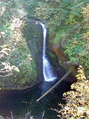
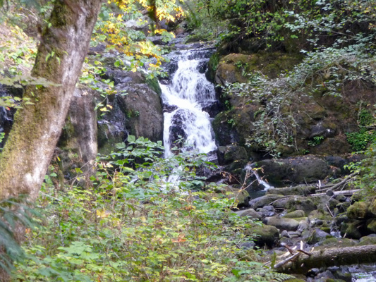
The trail crosses McDowell Creek to start with. Just downstream of the bridge is the Lower McDowell Creek Falls. There were people fishing below these falls, though I don’t know if they were catching anything.
The trail goes UP the hill and then crosses a small creek and gives you a view of Royal Terrace Falls. These falls can be very impressive in the spring (there were great photos of it in our hiking book) but clearly there was very little water in this side creek at this point.
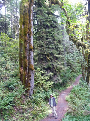
The trail then went back down hill and across McDowell Creek over a very fancy bridge and then back UP the hill and through a picnic area. Once we wound our way through the picnic area and across the parking lot we crossed the road to find the trail again. The trail went through wonderful grove of old mature Big Leaf Maples.
And a short time later we got a quick view of the falls at the Crystal Pool. We never did get a clear view the pool itself though.
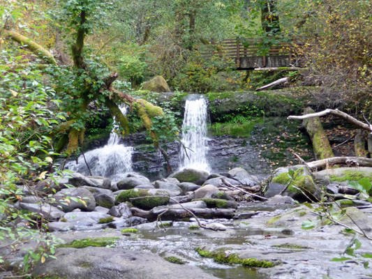
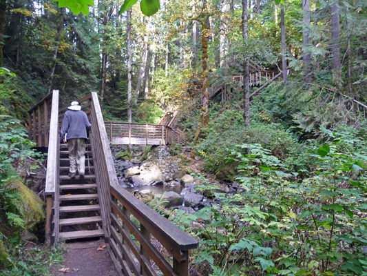
The trail then goes up the hill through several steep switchbacks and arrives in time at this large bridge with stairs leading up the cliff on the other side.
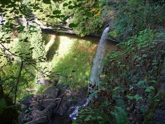
Up the first set of stairs after the bridge is a viewpoint for Majestic Falls.
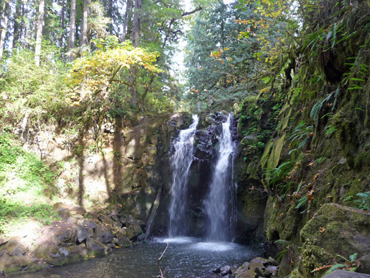
I suspect that these falls are REALLY impressive when there’s a lot of water in McDowell Creek.
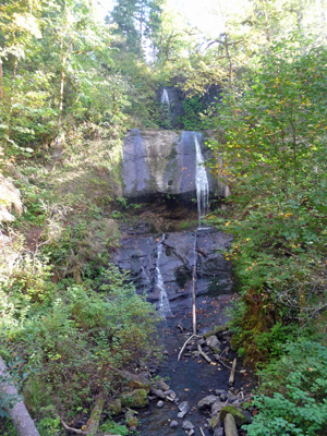
We climbed the stairs and arrived at a viewing platform at the top of the falls.
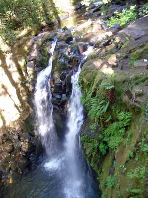
I climbed around on the rocks at the top of the falls because there were nifty round holes here and there that I thought were cool and in the end got this shot.
We climbed one more set of stairs and arrived at yet another picnic area and parking lot. You can go back across the road and take the trail UP to the top of the ridge and then DOWN again or you can follow the road back down the hill. We opted for the road since we’d had enough of the up and down business already.
We stayed on at Waterloo Park for another night and had a down day (it rained in the night but the sun was at by 11 am) before heading south to the Roseburg area for more waterfalls!
Our first stop was in Covington WA to spend the day at the Airstream dealer where we had a number of issues repaired under warranty. We hung out at the library in the morning (free WiFi) and did errands in the afternoon and then spent the night at the Washington Land Yacht Harbor (yes, it’s an RV park dedicated to Airstream trailers). The sun had come out late in the afternoon, so we got to see the orange full moon as it rose but the fog and clouds came back in during the night.
On Wednesday morning we set out in the foggy overcast to head south. By the time we reached the Washington-Oregon border the sun was out and we had blue skies. Hurray! We got off I-205 in Portland at Clackamas and took the winding country bi-ways out to Silver Falls State Park outside of Silverton, OR. We’d camped and hiked here in June of 2004 and really enjoyed it so a return in the off season seemed like a good idea. We got a spot for two nights (they were full for the weekend!) only to find that there was a fiberglass trailer gathering going on so we were surrounded by Escapes and Casitas and a few other strange rigs we’d never seen before (though our next door neighbor was another Airstream).
The skies stayed clear and we got to see the full moon as it rose over the trees. It stayed clear that night so it was pretty cold in the morning but the blue skies were welcome. After having breakfast and making a picnic lunch we set out on our outing for the day.
First stop was the Day Use Area for the South Falls. There are over 10 waterfalls in Silver Falls State Park. The last time we were here we hiked the upper section of the Trail of 10 Falls and saw nearly all of the falls. This time we were cheating since we wanted to visit another set of waterfalls nearby. So we just stopped at the overlook of South Falls to catch a photo. The park is much more developed than it was 10 years ago. The original buildings here were built by the WPA and the CCC in the 1930’s. They seem to have been renovated in the last 10 years and everything looks very spiffy. The Café was even open for lunch and there was a Nature Store open too. The park is very popular in the summer and there are large group campgrounds and a conference center here too.
The hike out to the over look is short and paved with fancy pavers. There wasn’t a lot of water in the falls but enough to make me happy. The trees that had started to turn color added a nice touch of gold to things.
There’s no cell phone signal in the main portion of the park but if you drive west along the highway you come to the South Viewpoint where there is a signal. We stopped there to check the weather report for the next few days. Here’s Walter checking his email. The little antenna on the roof of the truck is for our signal booster. The service was slow but we got what we needed to plan the next few days of our trip.
While Walter played on the computer I wandered out to the viewpoint and took a panorama shot of the valley. They grow a whole lot of Christmas trees in the area. Some of them even had tags on them ready to be cut and hauled to market come November. They view them as a farm crop and you’ll see signs that say they grow Christmas trees and seed crops.
From here we set off west and then north to the town of Silverton so that we could meander out to Butte Creek Falls. We’d found the directions to this place in our 100 Classic Hikes of Oregon book and they were perfect. We even managed to find Crooked Finger Road which eventually became gravel. The spur off Crooked Finger to the trail head was washboard and wound through a very recent clear cut. But then the fun began. They were in the midst of re-grading the gravel road and there was a hummock of gravel down the middle of the 1 1/2 lane road. First I tried driving on the right side but there wasn’t enough room. So I drove part of the way with the hummock of gravel under the truck. But then it got too high and I was shaving off the top of it with the underside of the truck—which didn’t seem like a great idea. So I tried driving on the left side which mostly worked. That is until the grader came around the curve straight at us. Oops. I put the truck in 4 wheel drive (a first for me) and pulled over onto the grassy verge and stopped. The grader went on by and thankfully I easily got back on the road. Whew. When we drove out, the road was all nicely graded and the grader had disappeared. Maybe they will re-grade the washboard section next.
The trailhead for Butte Creek Falls was nicely marked and had space for maybe 4 cars. We were the only folks there. There was even a vault toilet that had just been cleaned (and it had toilet paper!). There was great fungus growing at the start of the trail.
The trail heads downhill fairly quickly and shortly you can hear the rush of water. To the left there is a short spur trail (which goes down some more) where you can view the Upper Butte Creek Falls.
You can go all the way down to the pool and play in the water if you want to.
The rainy season hasn’t begun in earnest yet so there’s not a lot of water in the falls but I kind of like these falls as they are, rather than gushing with tons of water. The area behind the falls that looks like a grotto was created by erosion. It turns out that this whole area has two layers of basalt laid down by the Cascade volcanoes 15-16 million years ago. In between the layers there’s about 20 feet of sand and that gets eroded by the waterfalls and makes these grottos.
We hiked back up the spur and on ahead to the point where there’s a sign that says this is the ‘end of the maintained trail’. You can hear the Lower Butte Falls but you can’t see them from here. If you follow the very clear trail on just a ways and out on a rocky ridge you can see the falls.
Walter stayed here and I scrambled a ways further out on the rocky spine so I could see the falls a bit better.
There was still a more faintly defined trail that scrambled down the cliff but I wasn’t interested in breaking my neck so I turned back.
We hiked back completing a nice loop that takes your up the hill and through the woods. This is a very nicely maintained trail with a very nice bridge near the falls. It’s only about .8 of mile but they consider it moderately strenuous because it’s pretty steep. It was a big surprise that it was in such great shape since it truly is out in the middle of nowhere. It and the nearby campground (3 sites) are run by the Oregon State Forestry Department since it’s in the Santiam State Forest. They’re doing a very nice job of it too.
We drove on down to the campground thinking we could have our picnic lunch there but discovered it was closed for the season. So we drove on back on Crooked Finger Road (can you tell I love that name) to the little town of Scott’s Mill and had our lunch at their city park. Then we made our way back to Silver Falls State Park and drove out to the trail head for North Falls. Walter took a little nap while I hiked out to the first place you could see the falls.
Then we stopped at the North Falls viewpoint to get a photo there. You can see that North Falls has a grotto behind it too. In fact, the trail goes behind the falls—we did that back in 2004.
If the weather had been going to hold we would have stayed and hiked part of the 10 Waterfalls Trail again. But with rain on the way and the fact that we couldn’t get a spot to camp for Friday night in the campground, we moved on to Waterloo Park and another great waterfall hike.
It was sunny and gorgeous again on Friday morning Oct 10th. We gave some of the Fiberglass Trailer Rally folks a tour of the Airstream before we set out and they told us about a really nice county park with electrical and water hook ups that was real near the waterfall hikes we wanted to do. We motored on down the blue highways to the little town of Waterloo and found the Waterloo County Park without any problems. Most of the sites were empty and one of the campground loops was closed for the winter so we found a nice big spot with no problem. This is a nicely laid out park with long paved sites and a nice grove of maples and alders in the middle. It’s on the Santiam River so there are lots of fisherman here.
We set up camp, registered and checked to see if we had a hot spot signal. YES! And we had cell phone signals too. Wow, what luxury. We checked our email and then set out for our waterfall hike for the day. We drove north and then east a ways to McDowell County Park. We found the lower picnic area and with a little searching around found the trail head.
The trail crosses McDowell Creek to start with. Just downstream of the bridge is the Lower McDowell Creek Falls. There were people fishing below these falls, though I don’t know if they were catching anything.
The trail goes UP the hill and then crosses a small creek and gives you a view of Royal Terrace Falls. These falls can be very impressive in the spring (there were great photos of it in our hiking book) but clearly there was very little water in this side creek at this point.
The trail then went back down hill and across McDowell Creek over a very fancy bridge and then back UP the hill and through a picnic area. Once we wound our way through the picnic area and across the parking lot we crossed the road to find the trail again. The trail went through wonderful grove of old mature Big Leaf Maples.
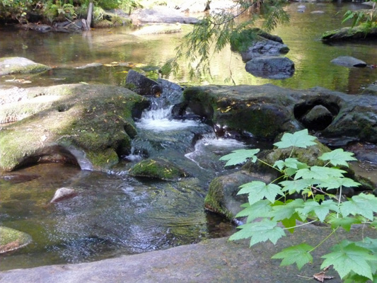
And a short time later we got a quick view of the falls at the Crystal Pool. We never did get a clear view the pool itself though.
The trail then goes up the hill through several steep switchbacks and arrives in time at this large bridge with stairs leading up the cliff on the other side.
Up the first set of stairs after the bridge is a viewpoint for Majestic Falls.
I suspect that these falls are REALLY impressive when there’s a lot of water in McDowell Creek.
We climbed the stairs and arrived at a viewing platform at the top of the falls.
I climbed around on the rocks at the top of the falls because there were nifty round holes here and there that I thought were cool and in the end got this shot.
We climbed one more set of stairs and arrived at yet another picnic area and parking lot. You can go back across the road and take the trail UP to the top of the ridge and then DOWN again or you can follow the road back down the hill. We opted for the road since we’d had enough of the up and down business already.
We stayed on at Waterloo Park for another night and had a down day (it rained in the night but the sun was at by 11 am) before heading south to the Roseburg area for more waterfalls!