
Mitchell was ‘interesting’ to put it nicely. The town looks like it’s about to close up and fall down all at once. The city park campground consisted of a small gravel parking lot with a few electrical boxes right at ground level. We pulled in since there was nowhere else in town to turn around and had to perform a 3 point turn just to get out again. If we’d parked there, we’d have taken up the entire ‘campground’. It was simply a ‘no way’ for both of us.
The reason for camping at Mitchell is that it’s only a few miles from the Painted Hills Unit of the Fossil Beds. There’s only a gravel road into this unit and we weren’t willing to take Genevieve in there. I’d hoped to get photos in the sun there but since it was raining, just as it was back 4 years ago when we last visited, it was no big loss to give it a pass. If you’d like to see what they look like go to my report on John Day from back in 2010 at http://walterandsara.com/AZ-6-2010.html
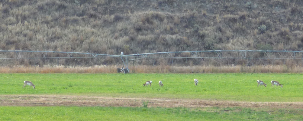
We drove on through Dayville (motto ‘All our fossils are friendly’—with drawing of old guys drinking coffee) and through an area where there are tons of signs telling you to watch for wildlife. We saw a large flock of wild turkeys first and then a big herd of antelope feeding out in an alfalfa field. Just before the town of Mt. Vernon we saw yet another small flock of turkeys.
We opted to camp at Clyde Holliday State Park. It’s a nice wayside park with electrical and water hook ups along the John Day River. We found a nice big back-in site (for only $20 a night since it’s the off season) and set up camp. When we went to register we stopped by and talked to the Camp Host. She’s been a host here each October for the last several years. Her husband hunts (deer and then elk) while she plays host. The park has a couple of teepees (cabins) that she had to take care of until they closed them around Oct. 15th. But otherwise it’s the usual meet and greet and make sure there’s toilet paper in the bathrooms routine. Her sister is the regional manager for the camp host program in this area so we got some good information about the local state parks and hosting jobs.
We had a few showers in the night but there were sun breaks when we got up and while it was really windy it wasn’t raining. As we were eating our breakfast there was a knock on our door. It was the camp hosts for the Kam Wah Chung State Historic Site (in John Day) who camp at Clyde Holliday since there is no camping at Kam Wah Chung. The Holliday host had mentioned our interest in talking to hosts and had sent them to see us. So after breakfast we walked over to talk to them. Their duties at the historical site were interesting. He managed the visitor center, showing the films and sending folks for the tour when the ranger was ready for them. She was working in the office double checking the cataloging of the huge archive of documents that are associated with the site. They’d been there just for the month of Oct. Before that they’d been out at the Sumpter Valley Dredge SHA (another day use only park) for September and the Emigrant Springs Campground for July and August as camp hosts. They’ll spend November at Honeyman State Park running the store there.
They gave us some info on the ins and outs of applying for hosting jobs with the Oregon State Parks and were all around interesting and informative. When we were done visiting with them we set out for the town of John Day to get gas and to check our email at the public library since it had been over 3 days since we’d had a decent internet connection. The library was closed but due to open in the afternoon so we opted to go to the Sheep Rock Unit of the John Day Fossil Beds and do a hike and come back to the library later.
As we drove past the alfalfa fields we spied the antelope herd once more and Walter pulled over and I scurried across the highway. There were bushes in the way (of course) but I did manage to catch 6 of them as they grazed.
I walked a little further along the highway and was just beginning to take a photo of the larger portion of the herd when they noticed me and off they went.
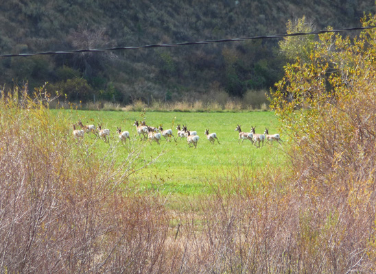
They are incredibly fast and in no time at all they had gone the length of the field and had charged up the game trail into the dry grasslands above. Poof. Gone.
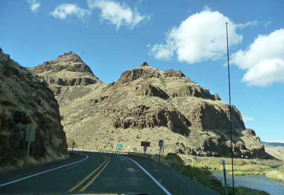
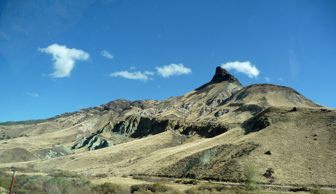
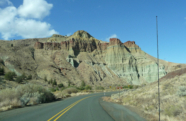
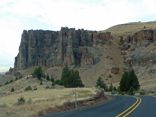
We drove on happy that we’d gotten to see them again. Later we saw a couple of elk along the way too. The road into the Sheep Rock Unit of the John Day Fossil Beds goes through what is called Picture Gorge. It’s a canyon of Picture Gorge Basalt where there are Native American pictographs high up on the walls. They won’t let you stop in the gorge so I snapped a photo through the car window as we went through. That’s the John Day River over on the right. It’s just starting to make it’s way northward here on its way up to the Columbia.
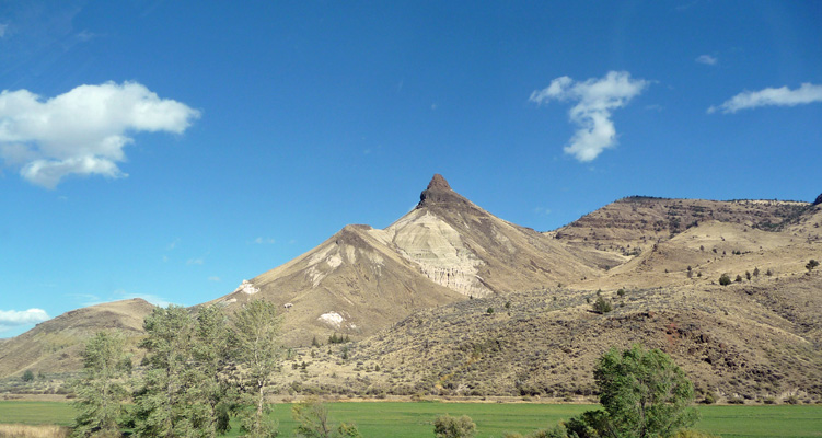
The road turns north after the gorge and you come to views of Sheep Rock, that pointy feature in the middle of the photo.
As you go past it you get to see a set of colorful deposits on it’s north face.
The Visitor’s Center here is really wonderful. It has great fossil plant displays and a fossil lab with a glass wall so you can watch the folks working. We really enjoyed it the last time we were here. This time we passed it on by and continued northward past Blue Basin where we hiked 4 years ago and on to Cathedral Rock.
Our destination was the Foree Picnic Area where there are two short hikes we didn’t have time for the last time we were here. It was really windy by the time we got here but we decided that it would only make things more interesting so we set out first on the Story in Stone Trail.
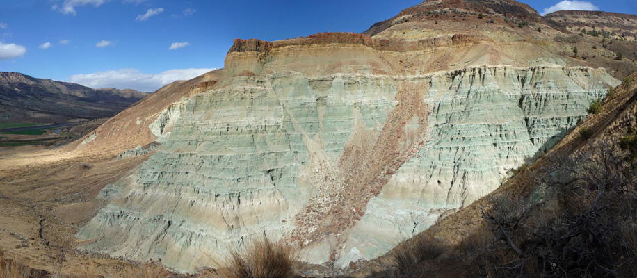
Erosion has revealed some really cool green formations here.
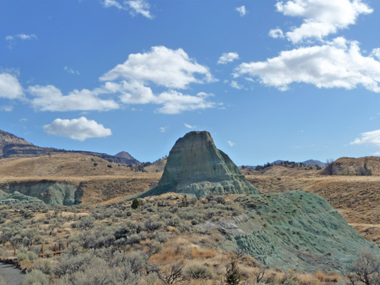
The trail is only about 1/2 mile and goes out to a viewpoint of a nicely eroded green hillside.
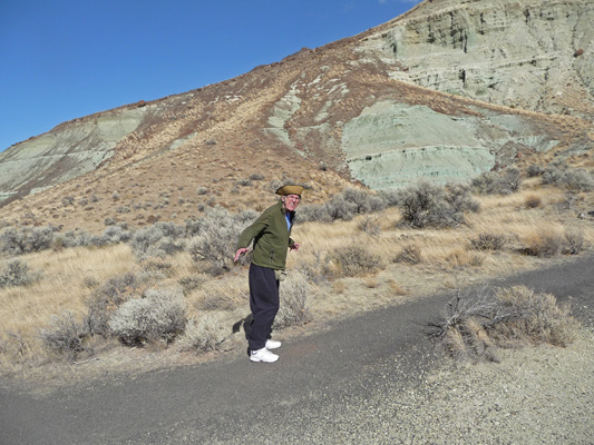
It’s a paved trail and gently uphill but we were walking straight into a really brisk wind—witness Walter’s hat brim and him trying to fly.
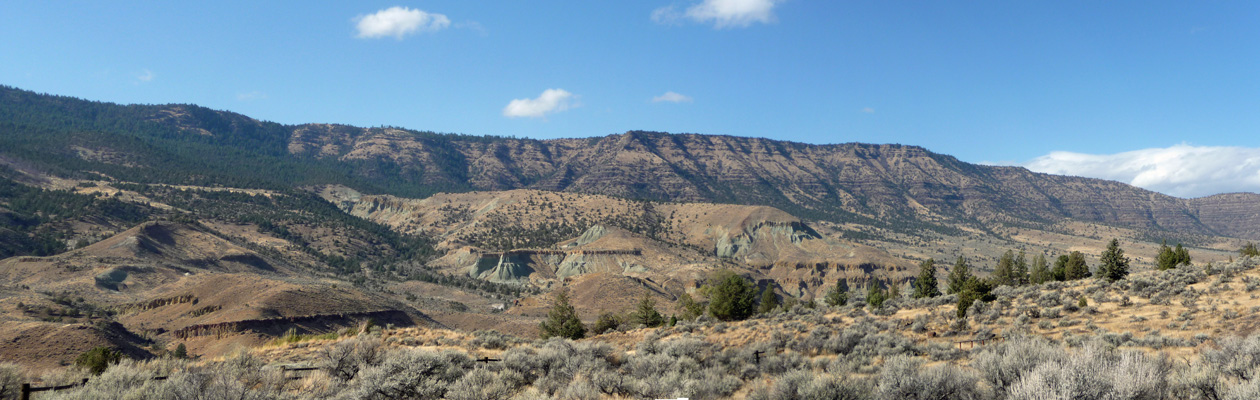
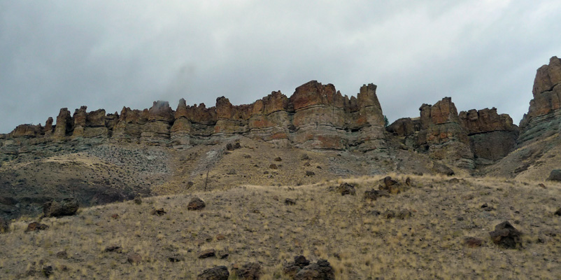
The view across the valley is lovely too. The brown striations on the hills across the valley are deposits of Picture Gorge Basalt created during floods of basalt (lava) 12 to 17 million years ago. There are over 60 different flows of basalt recorded in the canyon walls here totaling over 1300 feet in depth.
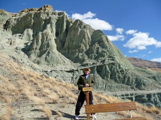
They kindly inform you when you get to the end of the trail. You can see how the wind is blowing all the grass over to the left. Walter thought that maybe he was supposed to sit on the bench here for the rest of his life since it said this was the end of the trail.
The green rock is formed from ash falls from volcanoes both to the east and west of here. The green is celadonite, resulting from water moving through alkaline volcanic ash.
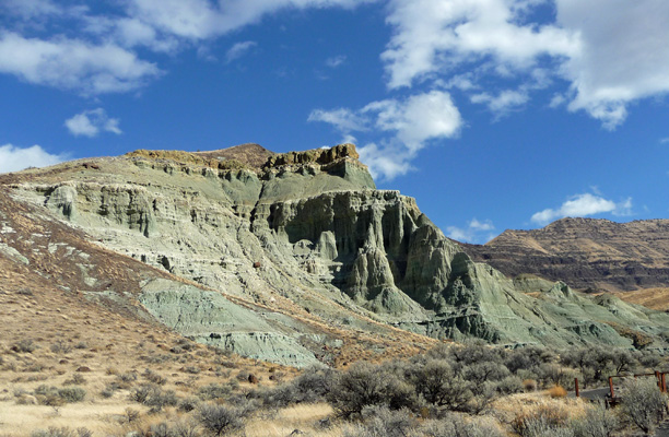
The walk back to the parking lot was a lot easier than going because we had the wind at our backs. We continued across the parking lot and started up the Flood of Fire Trail. This is another 1/2 mile trail (with a few stairs for variety) that takes you out to a viewpoint of a wonderful cliff face.
The white horizontal ridges in this formation are due to volcanic tuffs (like the Fort Rock formation we saw in the Oregon Outback). All tuff is, is a consolidated layer of volcanic ash and cinders. Tuff layers have a mineral called sanidine in them which is very easily dated using radioactive dating. So the tuff layers are a bit like horizontal bookmarks with dates attached that help geologists date the layers above and below them too—and thus date the fossils that are found there and the eruptions that laid down the ash and basalt. There’s over 50 million years of geologic history laid bare in this valley.
By the time we got back to the truck for our lunch (no we didn’t eat at the picnic tables out in the wind even if it was 60 degrees) the sun was gone and the colors became much more muted. We drove back the way we’d come and stopped at the library in John Day for email and to check the weather. It looked like things were wild and wooly up in Seattle (Saturday night lots of folks lost power in high winds and heavy rain) but the weather for our drive west and northward over the next two days looked good.
Sunday morning we had a couple of sun breaks as we packed up to go. We drove west along Highway 26 and once again saw antelope and elk and turkeys. Then we turned north again through the Sheep Rock Unit. We turned west and went through the town of Fossil and out past the Clarno Unit of the John Day Fossil Beds. Along the way we had a deer bound across the road (we were going slow and I saw her coming) and later we saw a pair of mountain goats just standing along a dirt road.
We stopped and hiked here 4 years ago and there are fossil leaves visible in the rocks along the trails. Both trails are worth the time and effort. One takes you across the bottom of this formation.
And the other takes you up through these.
The sun came and went over and over again on our drive and we had several good showers but for the most part it was a pretty pleasant drive.
As the day wore on we saw a great blue heron, a couple of hawks and a turkey vulture. A very good wildlife day.
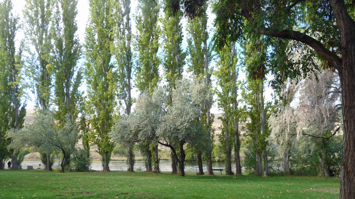
We finished the day at the Deschutes River State Recreation Area at the confluence of the Deschutes and Columbia Rivers. We got a nice long back-in site that was really easy to get into. We had a view of the Deschutes from our kitchen window along with a little fall color.
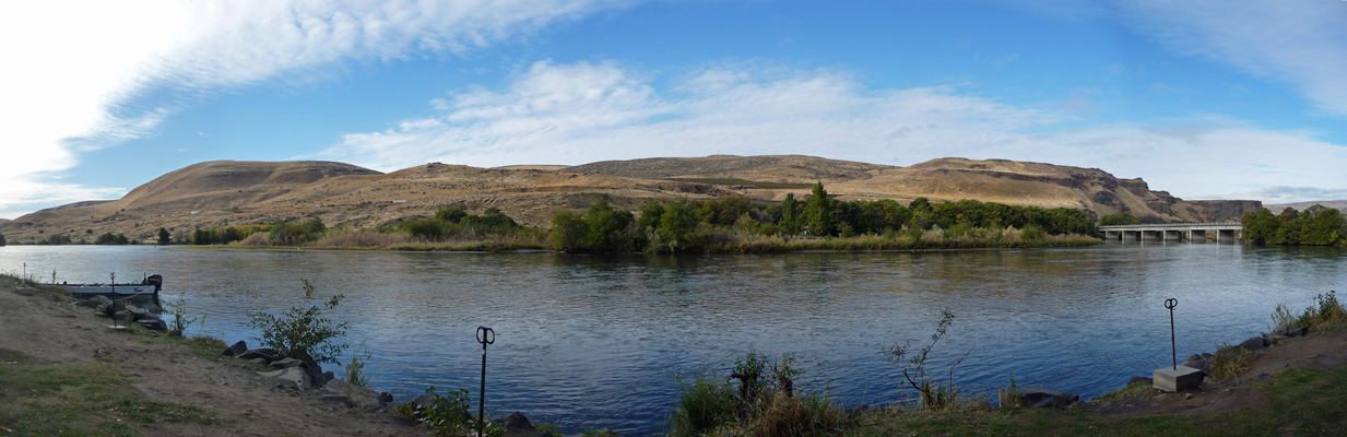
In the morning I walked down to the river to get this panorama shot. The fishermen here are fishing for steelhead. The Deschutes steelhead run is from July to October and is just about over. The only drawback to this campground is that you can hear the trains hurtle past nearby. But that is true at every campground along the Columbia Gorge so what the hey.
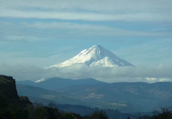
A fisherman stopped by as we were breaking camp and we gave him a tour of the Airstream. He was properly impressed and said he couldn’t let his wife see it because she’d want one. We drove west on I-84 until catching this view of Mt Hood with new snow on him.
we reached the turn off for Ainsworth State Park and the Historic Columbia River Highway. We’d planned on dropping the Airstream in the Day Use Area while we drove the old highway because it’s very narrow in places and has lots of twists and turns. But the Day Use Area was tiny and had trees that were too close for us to clear. So we drove on hoping we’d find some place further on to drop the trailer.
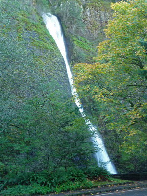
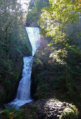
First stop along the way was Horsetail Falls. The parking lot was small but there were two short RV spots and Walter pulled into one and I hopped out and took a photo. The trees along the Columbia Gorge are just starting to show some fall color
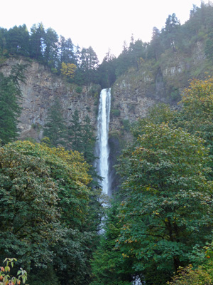
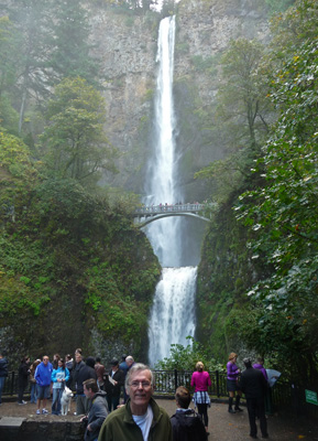
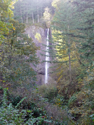
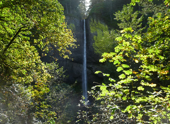
We drove on past the trailhead for Oneonta Falls because we really didn’t have time for a long hike and on to Multnomah Falls, the granddaddy of the waterfalls in the Gorge. We found a big spot along the highway (after going over a very narrow bridge where folks came to a stop so we could squeak by) and parked. We hiked on up the road to the falls. Your first view of the falls is from the parking area where you can see the top tier. The upper falls drop 542 feet from the top of the gorge.
There’s a paved pathway (with LOTS of tourists) that leads to the bottom of the falls. I took this panorama shot to get the entire falls at once. The lower falls drop 69 feet so the height of the falls is usually given as 620 feet.
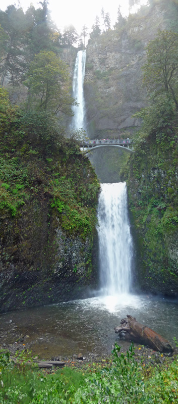
I took this shot of Walter and the crowds where you can actually see all of the falls at once.
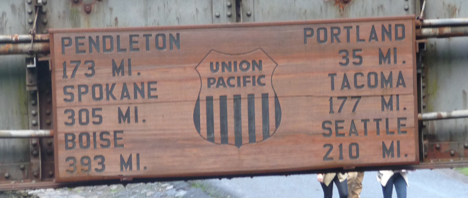
We walked back to the truck past the rail road trestle (there are tons of trains that go down both sides of The Gorge) and there was this fun sign with the distances to lots of local places on it.
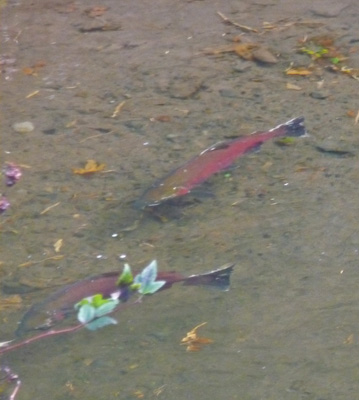
We crossed the stream that is fed by the falls and there were Coho salmon ready to spawn. Needless to say they’re not going to go very much further up stream here given the 620 feet of waterfall in their way.
We dropped the trailer when we got back and motored on westward on the historic highway. We passed Wahkeena Falls but they were working on the walkway and roadway in front of it so photos really weren’t possible. But when we got to the sign for Bridal Veil Falls we found a spot to park in the parking lot and took the 1/3 mile hike DOWN (including 45 stairs) to the stream and then back up (another 45 stairs) to see it.
There was sun filtering through the trees which lit up the fall color.
We hiked back up again and motored on by Shepherd’s Glen where there’s a nice cascade/waterfall that’s almost entirely hidden by the trees, so no photo. Finally we parked at Latourell Falls and I took this photo from the lower viewpoint.
Then I hiked up the STEEP path to the upper viewpoint. The sun was almost directly in my eyes and the camera was NOT happy. So I shaded it with my hand and actually got a decent photo along with the gorgeous fall color (Big Leaf Maples).
It was getting late and we had many miles to drive yet for the day so we turned around here. You can drive on and go up to the Vista House at the TOP of The Gorge if you like. The clouds were coming in so I’m not sure how great a view we would have gotten anyway. We drove back to the Airstream, had lunch and then hooked her back up to the truck. Then we had to drive back to Ainsworth so we could get back on I-84.
I had remembered getting off of I-84 to visit Multnomah Falls in the past so I was puzzled as to where the on-ramps had gone. When we got on the freeway and drove west, I figured it out. From I-84 you can get off the freeway from the fast lanes and park in the middle between the east and west bound lanes. There’s a tunnel you go through to get under the eastbound lanes and over to the falls. You can’t go anywhere else but the parking lot here! Ah ha! That’s why we couldn’t find the freeway entrance.
We drove into Portland and then north on I-5 to Silver Lake, WA and camped at the Silver Cover RV Park. We’d stayed here in August when we went to Mt. St. Helens and knew it would be an okay place for the night (and they had winter rates so it was less than $28 a night).
We’re heading back to Seattle for a couple of weeks. Walter gets his final post-cataract surgery eye exam on Wednesday and they’ll order new glasses for him. Then we get to wait for them to come. We’re not sure what we’ll be doing in the rainy weather while we wait but we’ll figure something out. When that’s done, we’ll be heading south for the winter.