
After spending a rainy night in Eugene, we drove to McArthur-Burney Falls State Park just north of Lassen. It was in the 80's and simply gorgeous. Shorts in September, yes!
It was Saturday and there were quite a few folks camped in the park--getting away from the heat in Redding. With a bit of searching we got a nice campsite and then hiked back to the park entrance to register and have a look at the falls.
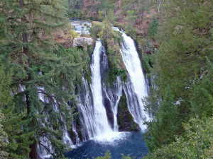
This is the view from the rim of the canyon. That's a lot of water for a waterfall in late September in California. It's because it's fed by springs just above the falls. In fact, 1/2 mile upstream, Burney Creek is usually totally dry this time of year, while tons of water goes over the falls.
There's a nice trail that leads down the 129 feet in elevation to the bottom of the falls. The temperature drops big time (the water never gets above 48 degrees) with Mother Nature's air conditioning working over time.
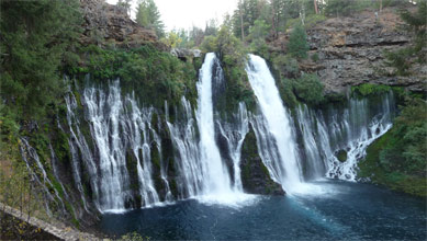
Here's the view from the bottom. The water on the sides is fed by more springs and on the far canyon wall springs continue to produce water for several hundred more feet down the canyon. 100 million gallons of water a day flows over these falls! That's a lot of water.
It was really dark (new moon) and clear that night and we could see lots of stars.
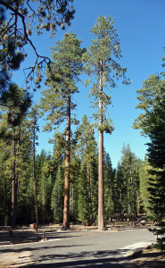
The next morning we motored on to Manzanita Lake at the north entrance of Lassen Volcanic National Park. The campground was pretty empty and we found a nice spot next to a HUGE Ponderosa Pine.
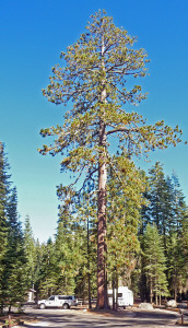
Yes, that's our pickup and Rosita down there at the bottom! From our windows we could see across the campground to these two big guys.
We stayed here for 4 days and had no neighbors the entire time. It was quiet and peaceful and lovely. High temps in the low 90's and lows of about 45 degrees. Clear nights with a wonderful view of the Milky Way.
After setting up camp we wandered around and checked out the lake. There was a bit of a breeze but nothing serious so after lunch we took the kayak out for a paddle.
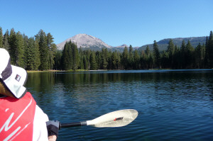
Walter sits in the front of the boat and I sit in the back. While we both paddle, the stronger partner sits up front while the weaker one sits in the back and steers with guidance from the front guy who actually can see what you might be about to run into.
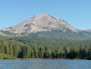
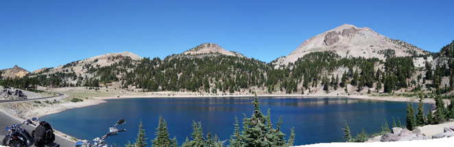
Here's the north face of Lassen from the kayak on Manzanita Lake. Timberline is about 9,000 feet here and the lake is at 5890 ft. The mountain is 10,462 feet high.
I put together this panorama shot from the kayak to give you a idea of the view. I love going out on the water like this so I can really see the views.
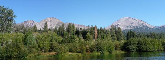
The Crags are on the left. They're an older volcanic formation that produced a huge rock avalanche about 350 years ago. Lassen is on the right.
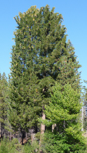
Big trees with drooping branches loaded with huge cones (over a foot long) clustered at the lake's edge. They are Sugar Pines, so called because they create huge amounts of sugary sap around the cones. I have a few at home that I collected in the Trinity Alps years ago. They make great Christmas decorations.

The next morning we packed a picnic lunch and set out to do the driving tour of the park. There's one main road that runs from north to south through the park. The first area you come to is the 'dwarf forest' growing the Chaos Jumbles, the area created by the avalanches from the Crags some 350 years ago. Since the area is covered very deeply in a jumble of rock the trees struggle to grow to any height. In fact, the area looks like a clear cut that has regrown for about 15 to 20 years (in Washington) when in fact, the trees are probably 290 years old!
Then you come to signs about the Devastated Area. This is the area that was wiped clean by the lahars and pyroclastic flows of mud, hot ash, pumice, rock and gas in the 1915 eruption of Lassen. At this point, it's growing back very nicely. I suspect in another 10 years people will have a really hard time understanding why it's called the Devastated Area.

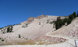
Here's a view of Lassen from the Devastated Area parking lot. As you can see, the trees are pretty good sized at this point. But you can also see the section of Lassen that collapsed and roared down through the area in 1915. It was the 1914-1915 eruption that led to the establishment of the National Park.
One of the favorite things that people do at Lassen is climb the peak itself. A 3 mile long trail leads from a parking area at about 8500 ft to the summit at 10,462 feet.
Here's the trailhead. No one was hiking the trail because it was closed 1 1/2 miles up the mountain by a rock fall and won't be open again until next spring. That's okay, we weren't going to hike it anyway.
Next comes Lake Helen, a gorgeous sapphire colored lake with Lassen in the background.
It was named after the first white woman to climb Lassen, Helen Tanner Brodt.
Just around the corner from Lake Helen is the trailhead to Bumpus Hell. We'll be back later to do the hike but we stopped to read the signs and took this photo of an accidental that was carried down the mountain by a glacier 10,000 years ago.
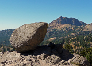
Behind it is Brokeoff Mountain, a part of a huge 6 mile wide 11,000 ft volcano, that dominated this area 400,000 years ago.
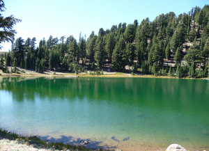
Around the next bend is Emerald Lake, a small shallow glacial cirque made green by the algae that can grow in it because it's shallow enough to warm up each summer.
The southwest side of Lassen has a great deal of geothermal activity. Off and on you can smell the rotten egg smell of sulfur wafting up the mountain.
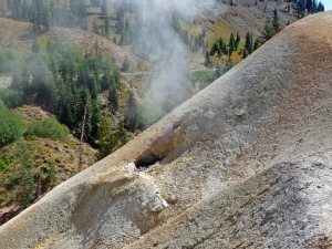
The Sulfur Works is a geothermal area right next to the road. In the past, you could walk the boardwalks up through the Sulfur Works but those areas are closed right now because the super heated water is re-routing itself and causing instability in the crust.
In fact, earlier in the season this feature had been disgorging huge amounts of water right onto the sidewalk along the road.
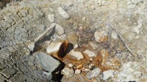
This day is was just hissing madly and putting out lots of steam.
Across the street, this guy howled and made a big stink.
I walked down the road a bit to get this photo of the area on the south side of the road. There's much more on the north side of the road that is currently closed to foot traffic.
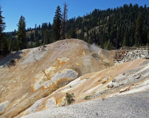
It's called the sulfur works because early in the century it was privately owned and mined for the sulfur.
From here we drove on down to the new Visitor's Center near the park's south entrance. It has a nice little museum with info on volcanoes and geothermal science. It turns out that Lassen is the one of largest plug dome volcanoes (if not the largest) and the park has examples of all 4 kinds of volcanoes that exist in the world. A volcanologist's paradise and good reason while the place is a National Volcanic Park.
From here we took a side trip to Mill Creek, a small summer home area on land leased from the Forest Service just south of the park. Walter's grandparents built a home here in the 1940's and retired there in the 1950's. Even though most of the houses are summer homes they lived there year round for many years. He has fond memories of visiting them to go fishing, hunting and playing in the snow for many years.
We drove around until we found what he thought was their house and talked to one of the workman who was there who didn't know much but that didn't seem to matter. Walter recognized the house and the hill they used to toboggan and ski on. A nice trip down memory lane.
We had our picnic with a view of the mountain back at the Visitor Center and then made our way back to Manzanita Lake stopping at the sights we had missed on the way there.
Here's a view of Lassen from Kings Creek Meadow.

love how the creek meanders all over the meadow before it heads further down the mountain. There's a popular hike that starts here and goes to a water fall and flower-filled meadows in the summer.
Our last stop for the day was Hot Rock.
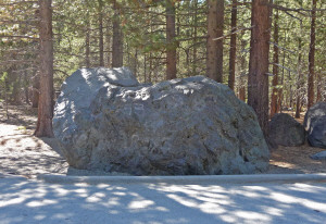
This is a large 30 ton boulder that was carried down the mountain by a lahar in the 1915 eruption. It was photographed by B.F. Loomis (a fellow who documented much of the eruption of 1914 and 1915) 2 days after the lahar and the mud around the rock was still boiling. The area around it is littered with more boulders from the mountain top.
In Part II, we'll tell you about Bumpus Hell, the largest hydrothermal area west of Yellowstone! And we'll go on a hike to three waterfalls along the McCloud River south of Mt. Shasta!